


3.3 km | 6.6 km-effort
![Trail On foot Pec pod Sněžkou - [Č] Okruh Zeleným a Modrým dolem - Photo](https://media.geolcdn.com/t/1900/400/c2b210e4-6037-49b5-a421-9b026ee9d52e.jpeg&format=pjpeg&maxdim=2)

Tous les sentiers balisés d’Europe GUIDE+


FREE GPS app for hiking
 SityTrail
IGN / Geographical institutes
SityTrail World
The world is yours!
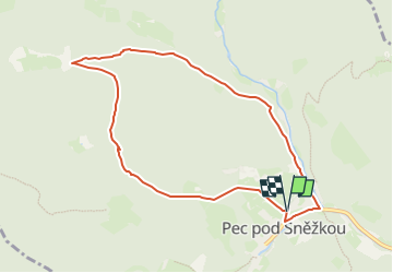
Trail On foot of 7.9 km to be discovered at Northeast, Královéhradecký kraj, Pec pod Sněžkou. This trail is proposed by SityTrail - itinéraires balisés pédestres.
Trail created by cz:KČT.
![Trail On foot Pec pod Sněžkou - [Č] Okruh Zeleným a Modrým dolem - Photo 1](https://media.geolcdn.com/t/2048/auto/b3dcd320-8a72-4c4d-8b43-c1be7c73a78e.jpeg&format=jpg&maxdim=0 "Trail On foot Pec pod Sněžkou - [Č] Okruh Zeleným a Modrým dolem - Photo 1")
![Trail On foot Pec pod Sněžkou - [Č] Okruh Zeleným a Modrým dolem - Photo 2](https://media.geolcdn.com/t/2048/auto/9fea6c48-5c21-4c98-952d-4acda165acd2.jpeg&format=jpg&maxdim=0 "Trail On foot Pec pod Sněžkou - [Č] Okruh Zeleným a Modrým dolem - Photo 2")
![Trail On foot Pec pod Sněžkou - [Č] Okruh Zeleným a Modrým dolem - Photo 3](https://media.geolcdn.com/t/2048/auto/62ff41e4-91e6-482b-91bb-e90bef5b9e07.jpeg&format=jpg&maxdim=0 "Trail On foot Pec pod Sněžkou - [Č] Okruh Zeleným a Modrým dolem - Photo 3")
![Trail On foot Pec pod Sněžkou - [Č] Okruh Zeleným a Modrým dolem - Photo 4](https://media.geolcdn.com/t/2048/auto/8f0d3d4e-d47e-4242-bf76-5bce64945b70.jpeg&format=jpg&maxdim=0 "Trail On foot Pec pod Sněžkou - [Č] Okruh Zeleným a Modrým dolem - Photo 4")
![Trail On foot Pec pod Sněžkou - [Č] Okruh Zeleným a Modrým dolem - Photo 5](https://media.geolcdn.com/t/2048/auto/992a744a-0b7b-4236-b376-60b1adc181c0.jpeg&format=jpg&maxdim=0 "Trail On foot Pec pod Sněžkou - [Č] Okruh Zeleným a Modrým dolem - Photo 5")
![Trail On foot Pec pod Sněžkou - [Č] Okruh Zeleným a Modrým dolem - Photo 6](https://media.geolcdn.com/t/2048/auto/55909909-aa3c-448b-9c16-e75d769d2b87.jpeg&format=jpg&maxdim=0 "Trail On foot Pec pod Sněžkou - [Č] Okruh Zeleným a Modrým dolem - Photo 6")
![Trail On foot Pec pod Sněžkou - [Č] Okruh Zeleným a Modrým dolem - Photo 7](https://media.geolcdn.com/t/2048/auto/7a910120-d646-479c-8316-e371bf660594.jpeg&format=jpg&maxdim=0 "Trail On foot Pec pod Sněžkou - [Č] Okruh Zeleným a Modrým dolem - Photo 7")
![Trail On foot Pec pod Sněžkou - [Č] Okruh Zeleným a Modrým dolem - Photo 8](https://media.geolcdn.com/t/2048/auto/b0182e4b-b31a-49e1-8c43-68d9b3309e65.jpeg&format=jpg&maxdim=0 "Trail On foot Pec pod Sněžkou - [Č] Okruh Zeleným a Modrým dolem - Photo 8")
![Trail On foot Pec pod Sněžkou - [Č] Okruh Zeleným a Modrým dolem - Photo 9](https://media.geolcdn.com/t/2048/auto/4af9e12d-f3de-47e5-8d34-47d8df40273c.jpeg&format=jpg&maxdim=0 "Trail On foot Pec pod Sněžkou - [Č] Okruh Zeleným a Modrým dolem - Photo 9")
![Trail On foot Pec pod Sněžkou - [Č] Okruh Zeleným a Modrým dolem - Photo 10](https://media.geolcdn.com/t/2048/auto/c2b210e4-6037-49b5-a421-9b026ee9d52e.jpeg&format=jpg&maxdim=0 "Trail On foot Pec pod Sněžkou - [Č] Okruh Zeleným a Modrým dolem - Photo 10")
![Trail On foot Pec pod Sněžkou - [Ž] Lesní bouda - Pec pod Sněžkou - Photo](https://media.geolcdn.com/t/375/260/70d52730-fa8e-459c-b700-dda483ba92d1.jpeg&format=jpg&maxdim=2)
On foot
![Trail On foot Pec pod Sněžkou - [M] Pec pod Sněžkou - Obří sedlo - Photo](https://media.geolcdn.com/t/375/260/32778c97-e2a1-454a-93e6-a211dcd26ef5.jpeg&format=jpg&maxdim=2)
On foot
![Trail On foot Pec pod Sněžkou - [Ž] Kubátova cesta - Photo](https://media.geolcdn.com/t/375/260/efda0a63-187b-4e67-b028-1c73de146c02.jpeg&format=jpg&maxdim=2)
On foot